Native Trout Conservation in the Anthropocene
How massive wildfires affect native trout habitat and restoration efforts.
Written and Photographed by Danny White

A large plume of smoke rose over Fort Collins as the Cameron Peak Fire made a run as 50 mph wind gusts fanned the flames
A few miles west of Fort Collins, Colorado, a billowing smoke plume extended in all directions. The August afternoon felt like a smoky red blanket had been draped across the Front Range. Ash fell from the sky covering everything in a thin layer of grey specks. 2020 was the worst fire season ever recorded in Colorado. Three fires had a significant impact on rivers in Northern Colorado, all burning within 50 miles of each other. The Cameron Peak Fire burned 208,913 high elevation acres of the Wild and Scenic, Cache la Poudre River watershed. The East Troublesome Fire burned 193,812 acres of the Upper Colorado River watershed, passing into Rocky Mountain National Park. The Mullen Fire burned 176,878 acres of Northern Colorado and Wyoming’s Upper North Platte Watershed.
These recent large, high intensity wildfires in western North America are the result of complex dynamics between modern forest management and climate change. The effects of climate change are widespread and symptoms clearly manifest. Specifically, longer summers means a longer fire season and an explosion of Mountain Pine Beetle populations leaving large swaths of montane forest grey, dead, and dry. The changing frequency, severity, and size of wildfires has significant impacts on stream and watershed processes that pose a threat to the existence of some native trout. Although many natural systems are inherently resilient, some situations are highly sensitive to the effects of wildfires. These impacts are compounded by changing weather patterns causing earlier snowmelt runoff, and extreme precipitation events.

Water quality and habitat monitoring sites in the Poudre Canyon. See the inset legend for more information.
As organic material burns during high intensity fires, an oily substance is often released creating a hydrophobic surface. When rain falls on this bare, oily surface, its ability to infiltrate into the soil is limited, instead flowing quickly and converging into larger streams. Ash and other ‘O’ horizon soils are highly erodible and susceptible to transport to perennial water sources where trout and other aquatic organisms live. With ash entering normally crystal clear waterways, it often turns black with a muddy consistency. Nutrients such as dissolved organic carbon (DOC), nitrate (NO3), and phosphate (PO4) can rise to intolerable levels for trout.
During the summer of 2021, a group of researchers based in the Fort Collins area watched the weather forecast with anticipation, speculating about the fate of a sensitive population of Greenback Cutthroat Trout, Onchorynchus clarkii stomias (GBCT). Although the GBCT species is not currently federally listed as Endangered, there are only a handful of populations in existence. In 2007, a study showed that only one genetically pure population of GBCT existed in a tiny creek, outside its native range. Since then, an interagency effort to reintroduce the fish has begun and the headwaters of the Poudre River drainage were identified as the target for a basin scale restoration initiative.

Greenback Cutthroat Trout, Onchorynchus clarkii stomias, carried in backpacks were reintroduced to Roaring Creek, a tributary of the Cache la Poudre River the summer before the Cameron Peak Fire burned the same watershed.
Roaring Creek, a tributary of the Poudre River, is one location where GBCT have been reintroduced. In summer 2020, before the Cameron Peak Fire, GBCT were carried in backpacks up a steep trail into the East Fork of Roaring Creek. It is also a sampling site for Science on the Fly and the location where an ongoing GBCT habitat suitability study is being performed. The habitat study uses projected stream flow metrics under varied climate change scenarios to identify suitable restoration sites. The study aims to inform management practices for the GBCT and other sensitive native trout species.
Roaring Creek and the few locations where Greenback have been reintroduced are particularly susceptible to environmental stressors due to the species’ small gene pool. This means that with the increased probability of wild stream temperature fluctuations, high pollutant loads, and altered hydrology, small isolated populations could face extinction.
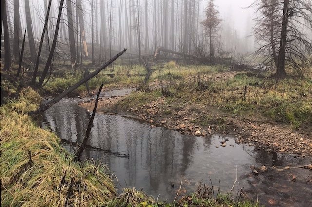
From the summer of 2019 to 2021, I visited Roaring Creek multiple times to measure flow depth, water temperature and collect Science on the Fly water quality samples. During the Cameron Peak Fire, the Roaring Creek Trail was destroyed. Forest management agencies closed the trailhead because of treefall danger and it remained closed for the majority of summer 2021. As soon as it was opened after some trail maintenance was performed, I hiked in to look for any signs of GBCT as well as the data loggers we had installed at the habitat study site. I wasn’t sure I would find anything. The watershed was completely torched. Although wildfire is a natural process, massive, high severity burns that leave entire forests dead can cause irreversible change.
I bushwacked to the study site, climbing over, under and around deadfall. Hiking in these conditions left me covered in ash and I felt like a ghost, alone in the charred landscape. I noticed recent beaver chew, a small, but hopeful sign of life. I was shocked to see three Dusky Grouse perched on a burned log. They seemed to be shocked by my presence and didn’t move from their perch as I walked past. Ash covered the stream bed and I saw no sign of trout. It seemed the survival of the reintroduced GBCT in this watershed was unlikely.

Two photos taken at the same location on West Fork Roaring Creek show the dramatic change large wildfires cause.
The habitat monitoring site was nearly unrecognizable. I felt as if I had come to confirm the identity of a deceased acquaintance. The willows that had previously lined the banks were gone. The Douglas Firs, Blue Spruce, and pines looked like black painted toothpicks, completely stripped of branches. Wading through our study reach, I was somehow able to locate the sensor that we had anchored to the bed two summers ago. We would be able to get a glimpse into the state of the stream during the period of months after the fire thanks to the data that had been stored on the logger.
It wasn’t surprising to see that the stream temperature jumped by 6 degrees Celsius as the fire ripped through the study site. However, I didn’t expect the rapid decrease in temperature for a day or so after the site burned. This may have been a result of the massive smoke cloud that blocked the sun for days, shading the stream. Although the stream temperature didn’t rise to levels that cause trout mortality, the dramatic swing of 18 to 2 degrees Celsius over the course of a day likely stressed the fish.

Stream temperature monitored in Roaring Creek, a tributary of the Poudre River. Much of the Roaring Creek watershed burned at high severity in the Cameron Peak Fire. The orange asterisk denotes the date and peak temperature reached in the stream as forest burned.
The City of Fort Collins monitors turbidity a few miles downstream of Roaring Creek’s confluence with the Poudre River. As has been the case with other wildfires in Colorado, the highest turbidity was measured during and after isolated thunderstorms that mobilize large volumes of fine sediment. At some point during the summer, most major contributing tributaries, including Roaring Creek, received high inputs of ash, sediment and other material that decrease clarity and raise pollutant levels. In some instances, so much sediment and flow accumulate that deadly debris flows form, capable of carrying boulders the size of cars, and destroying homes in the floodplain. This was the case on July 20, 2021 at Black Hollow, a tributary of the Poudre River. Fine sediment dumped into the river after the debris flow at Black Hollow accumulated in pools and along the banks as far as 50 miles downstream.

Turbidity monitored by The City of Fort Collins. The increase and sustained elevated turbidity through late July and August are largely attributed to the pulse of fine sediment resulting from the debris flow at Black Hollow.
We observed an interesting phenomenon in person at another tributary of the Poudre River, that likely also occurred at Roaring Creek. On April 26, 46 days earlier than peak runoff occurred, the creek flooded, not because of a large flow event, but because of an uncharacteristically warm spell that quickly melted some of the snowpack. The high temperatures prematurely started runoff, even though the stream was locked up with ice. In the Southern Rockies, stream flow typically reaches its peak in early summer as the mountain snow melts.
At Roaring Creek, measured depth on April 26 (the date of flooding over ice), was even higher than peak runoff. This type of flooding could place pressure on already strained trout and other aquatic organisms. During the winter months, trout typically go into a state of energy conservation, hiding out where flow velocity is low. The cold water temperature also causes them to become somewhat more lethargic. A late winter flood over ice event could have been detrimental to the population of Greenback Cutthroat Trout that had been reintroduced the summer before. It is still unclear whether any of the GBCT survived the Cameron Peak Fire and its aftermath. Large floods remain a risk in highly burned watersheds for multiple years, so the impacts will be likely be felt until the forest achieves significant regrowth.

Stream depth from July 2019 to July 2021 at Roaring Creek. The blue dashed line indicates periods of freezing stream temperature which could affect the measured stage. The purple asterisk is the date Cameron Peak Fire burned through the watershed. Low volume flow over ice likely occurred on April 26, 2021, causing flooding.
One of the clear takeaways from observations made at Roaring Creek and other streams affected by the ravaging wildfires in the West is that there are natural regimes, or characteristic patterns of succession, that have occurred in watersheds and rivers throughout time. Trout, rivers, forests, and their encompassing watersheds have evolved to be suited to handle disturbances to hydrologic, fire, and other regimes. As we experience a changing climate and impose anthropogenic influence on natural regimes, riparian systems may not be capable of bouncing back due to the magnitude of disturbance. To understand the effects of climate change on riparian ecosystems, active monitoring and sharing the data collected with those in a position of influence is critical. Now is the time to be an active steward of the rivers and watersheds that we enjoy. We are cogs in the wheel that are causing change, both positive and negative. Active preservation, conservation, and restoration is critical.